Effective street networks provide connectivity for multiple users. Street networks should prioritise walking and cycling, which represent the plurality of trips and serve as the access modes for public transport.
Complete network configuration
Complete streets networks help create walkable communities where people are safe from traffic violence. In addition, street networks facilitate operations of high-quality public transport for longer trips and movement of motorised traffic at moderate speeds.
This section outlines the process to create a complete network that prioritises walking, cycling, and public transport. Motor vehicles are accommodated, but in a supportive role.
[drawattention ID=989]
Modal hierarchy
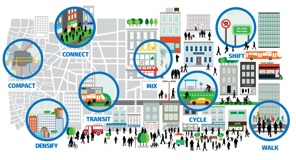
Decisions regarding the design and use of a city’s limited street space should prioritise walking, cycling, and public transport over private motor vehicles, following the street hierarchy of needs.
The sustainable long-term solution for efficient mobility is to invest in high-quality public transport and NMT facilities. Investment in flyovers and elevated highways may reduce congestion temporarily, but the sustainable alternative is to provide dedicated sufficient spaces for mass rapid transit (especially BRT), supported by comfortable, safe, and continuous walking and cycling facilities.

Public transport
The starting point of a complete network is public transport. Public transport can move large numbers of people quickly and efficiently in urban areas. A well-connected street network enables public transport to operate within walking distance of all urban residents. Street networks should enable public transport services to operate with direct routing and minimal detours. High-demand corridors can incorporate dedicated right-of-way services such as bus rapid transit (BRT) to enable buses to bypass traffic jams. On corridors with regular bus services, street designs should provide for convenient public transport access through shelters, signage, and safe pedestrian crossings. Public transport lines and stops must be spaced to balance speed (e.g., of BRT buses) and access (to the stop or station).

Walking
Walking is a dominant mode in Ethiopian cities, and public transport trips also start and end on foot. As a healthy and pollution-free form of mobility and recreation, walking is key to urban life. Pedestrian networks must have complete, publicly accessible walkways where all destinations are connected to each other and protected from vehicle traffic.
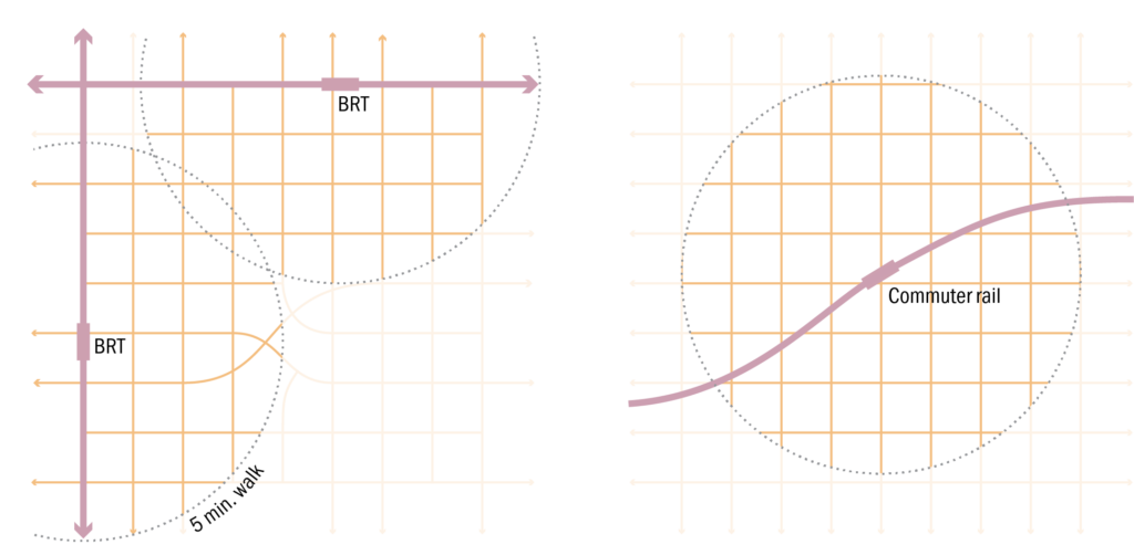
The figure below shows two versions of a representative transit-oriented district. On the left is a BRT system that plies the arterial street network. On the right is a rail-based system that does not follow the street network. Both have a network of streets and paths that lead to the rapid transit stations. Both diagrams use a 5-minute (400 m) walking radius.
Cycling
Greenways, paths, and other non-motorised transport facilities play a key role in complete networks. Cycling offers low-cost, pollution-free mobility. For cycling to be safe and comfortable for people of all ages, cities should create complete cycle networks serving all city areas and key destinations through the shortest possible routes. The cycle network can include various types of facilities, including slow-speed neighbourhood streets, physically separated cycle tracks on major streets, and cycle paths running through parks and greenways. The cycle network should be integrated with public transport systems and pedestrian priority areas. Secure cycle parking should be available at destinations.
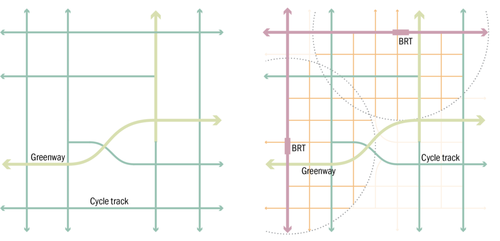
Below are the greenway and cycle track components of a complete network. The image on the left illustrates how cycling facilities may or may not follow the grid. Aside from corridors on streets, the cycle network can follow a river or railway tracks. On the right, the greenways are overlaid on the BRT-based transit-oriented grid.
Private vehicles
Complete networks accommodate motor vehicles, but in a supportive role. They are primarily for service and deliveries. Specific measures, including on-street parking systems and congestion charging, manage the overall use of personal motor vehicles. These measures should seek to cap the overall vehicle kilometres travelled by personal motor vehicles and limit the mode share of personal motor vehicles to at most 20 percent of daily trips.
The motorist network should provide access to the urban area while ensuring safety and efficient movement for pedestrians, cyclists, and public transport. A well-connected motor vehicle network can reduce bottlenecks and congestion. To ensure safety for all users, motor vehicle speeds must be managed carefully through traffic calming, appropriate street spacing, safe intersection designs, and automatic enforcement.
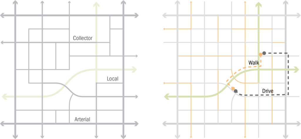
Interconnected walking networks with short block lengths allow for short and direct routes through neighbourhoods. As shown in the image above, it will often be faster to walk or cycle within the district. The centre of the community is highly “green”—oriented towards walking, cycling, and public transport. Fine-grained networks offer multiple routes to various destinations and make it convenient to complete trips by foot or cycle. In areas where large blocks exist, redevelopment provides an opportunity to break up large blocks to improve pedestrian connectivity.
Composite network
With the various components in hand, a composite network can be formed, as seen in the image below. The starting point is public transport, in this case, a surface-based BRT system (red) passing through the district, providing access to the majority of residents within a 5-minute walk of the stations. Emanating out from the stations are the principal walkways (yellow)—promenades for people accessing the station, and the signature streets of the district. Walking spurs connectivity to the streets through these walkways and provides access to all blocks and surrounding districts. Greenways (yellow-green) pass through the district, potentially along waterways. Cycleways (green) provide high-speed and comfortable passage for cyclists.

Cycling infrastructure also extends the reach of the BRT stations. A network for private vehicles circumscribes the district but does not interrupt it. Access is provided to all blocks, but drivers are channelled to the surrounding arterials. Motor vehicles support the neighbourhood but do not define it. The complete, transit-oriented district supports access for residents of all incomes, genders, and abilities.
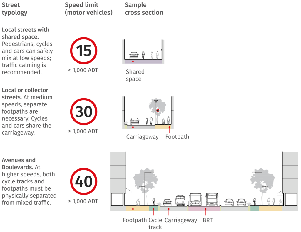
Street classification
The classification of streets is typically assigned at the urban planning stage based on socioeconomic characteristics, expected user volumes, existing and proposed land uses, topography, and the location of streets.
The national street classification system is important for funding, reporting, and bureaucratic requirements. However, urban streets are inherently multi-modal, and the functions for specific modes may not mirror the legal classification of the street. For example, a BRT system could ply on a Collector Street, thereby making it an “arterial” for public transport. Similarly, if an Principal Arterial Street has cycle tracks, then it would be an “arterial” for cyclists; otherwise not. The following are the categories of streets adopted in this manual and their respective roles.
Principal Arterial Street / Boulevard
(Godana)
A major corridor incorporating reserved space for trunk public transport services in the form of bus rapid transit (BRT) or dedicated bus lanes; dedicated space for cycling; and high-quality pedestrian space.
Collector Street
(Sebsabi Menged)
Street with optional public transport access; dedicated space for cycling or cycle access in a traffic calmed carriageway; and footpaths.
Network density
The following table identifies the appropriate spacing for different street typologies. Aside from these standards, spacing shall be based on the land uses, location, topographic conditions, and other local factors. Street layouts should adopt the most economical and efficient street arrangement. The minimum size of a block in urban centres and associations/cooperatives shall be 30 m, while the minimum size of blocks for commerce, business, administration, service and manufacturing shall be 40 m. The maximum size of a block face is 100 m in order to ensure that the street network offers a fine-grained network of pedestrian paths.
Type of street or facility | Classification | Spacing (m) |
Public transport | Express stop/station | 600-800 |
NMT | Cycleway | 150-200 |
Street (vehicle) | Principal Arterial Street | 1,000-1,500 250-500 |
Streets and land use
Streets shape land use and morphology of urban centres. At the same time, different land uses generate various mobility needs. Streets, land use and transport are thus related and their relationships affect the character of urban centres.
Transit-oriented development (TOD) is a way of planning cities and neighbourhoods based on the principle of integrating land uses (residences, activities, and open spaces) with public transport, supported by excellent walking and cycling facilities. This is achieved by concentrating urban densities, communities, and activities within a 5-10 minute walking distance of mass rapid transit stations, developing quality urban space, and providing convenient and efficient access to a diverse mix of land uses.
Historic streets
Street design can enhance the character of historic districts in Ethiopian cities. As much as practicable, streets in historic cities shall be pedestrianised. Historic streets with motor vehicle access should have flexible designs that facilitate temporary pedestrianisation during festivals. Maintenance and upgrading of streets in historic districts can make use of original materials and techniques.